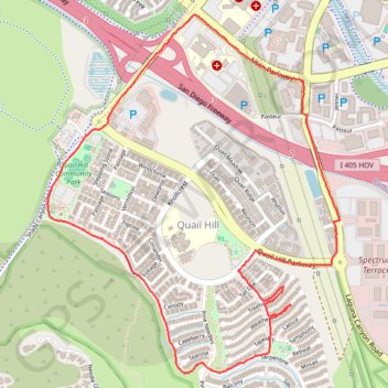
Quail Hill Loop
- Distance: 4.2 mi
- Elevation gain: 98 m
- Maximum elevation: 119 m
- Elevation loss: 99 m
- Minimum elevation: 46 m
- Moving time: 50 m 2 s
- Moving speed: 5.1 mph
- Maximum speed: 17.5 mph
- Total time: 50 m 2 s
- Global speed: 5.1 mph
Interactive trail map
Trail profile
- Distance: 4.2 mi
- Elevation gain: 98 m
- Maximum elevation: 119 m
- Elevation loss: 99 m
- Minimum elevation: 46 m
- Moving time: 50 m 2 s
- Moving speed: 5.1 mph
- Maximum speed: 17.5 mph
- Total time: 50 m 2 s
- Global speed: 5.1 mph
About this trail
Name: Quail Hill Loop trail, distance, elevation, map, profile, GPS track
Coordinates: 33.64196 -117.78413 33.65999 -117.76647
Other hiking, mountain biking, running and outdoor activity trails
Click on a trail to view its statistics, map and profile.
Bike ride on Santa Ana river trail to beach
United States > California > Orange County > Anaheim
Distance: 24.5 mi • Elevation gain: 77 m • Maximum elevation: 95 m
Quail Hill Open Space Reserve
United States > California > Orange County > Irvine
Distance: 4.5 mi • Elevation gain: 152 m • Maximum elevation: 110 m
Quail Hill - Turtle Rock
United States > California > Orange County > Irvine
Distance: 9.4 mi • Elevation gain: 169 m • Maximum elevation: 109 m
Oak Creek Loop
United States > California > Orange County > Irvine
Distance: 9.3 mi • Elevation gain: 60 m • Maximum elevation: 96 m
Quail Hill
United States > California > Orange County > Irvine
Distance: 11.3 mi • Elevation gain: 174 m • Maximum elevation: 109 m