Cardrona Forest
Evening Walk
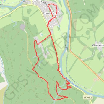
- Distance: 4.3 mi
- Elevation gain: 199 m
- Maximum elevation: 296 m
- Elevation loss: 198 m
- Minimum elevation: 148 m
- Moving time: 1 h 41 m
- Moving speed: 2.5 mph
- Maximum speed: 6.4 mph
- Total time: 1 h 53 m
- Global speed: 2.2 mph
Interactive trail map
Trail profile
- Distance: 4.3 mi
- Elevation gain: 199 m
- Maximum elevation: 296 m
- Elevation loss: 198 m
- Minimum elevation: 148 m
- Moving time: 1 h 41 m
- Moving speed: 2.5 mph
- Maximum speed: 6.4 mph
- Total time: 1 h 53 m
- Global speed: 2.2 mph
About this trail
Name: Cardrona Forest trail, distance, elevation, map, profile, GPS track
Coordinates: 55.62063 -3.11169 55.63949 -3.09832
Topography: Scottish Borders topographic map, elevation, terrain
Other hiking, mountain biking, running and outdoor activity trails
Click on a trail to view its statistics, map and profile.
Kailzie Gardens via Drive Wood and River Tweed
United Kingdom > Scotland > Scottish Borders > Cardrona
Distance: 4.1 mi • Elevation gain: 72 m • Maximum elevation: 184 m
Cardrona Forest - Wallace's Hill
United Kingdom > Scotland > Scottish Borders > Cardrona
Distance: 5.7 mi • Elevation gain: 321 m • Maximum elevation: 462 m
Cardrona to Glenormiston
United Kingdom > Scotland > Scottish Borders > Cardrona
Distance: 5.0 mi • Elevation gain: 106 m • Maximum elevation: 217 m