Thank you for supporting this site ❤️
Make a donation
Make a donation
Gear up for your next adventure:
As an Amazon Associate, this site earns from qualifying purchases at no extra cost to you.
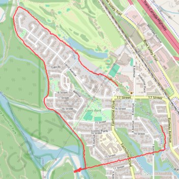
Canmore Walking Paths
- Distance: 2.7 mi
- Elevation gain: 11 m
- Maximum elevation: 1,321 m
- Elevation loss: 12 m
- Minimum elevation: 1,312 m
- Moving time: 1 h 12 m
- Moving speed: 2.2 mph
- Maximum speed: 5.1 mph
- Total time: 1 h 37 m
- Global speed: 1.6 mph
Interactive trail map
Thank you for supporting this site ❤️
Make a donation
Make a donation
Gear up for your next adventure:
As an Amazon Associate, this site earns from qualifying purchases at no extra cost to you.
Trail profile
- Distance: 2.7 mi
- Elevation gain: 11 m
- Maximum elevation: 1,321 m
- Elevation loss: 12 m
- Minimum elevation: 1,312 m
- Moving time: 1 h 12 m
- Moving speed: 2.2 mph
- Maximum speed: 5.1 mph
- Total time: 1 h 37 m
- Global speed: 1.6 mph
Thank you for supporting this site ❤️
Make a donation
Make a donation
Gear up for your next adventure:
As an Amazon Associate, this site earns from qualifying purchases at no extra cost to you.
About this trail
Name: Canmore Walking Paths trail, distance, elevation, map, profile, GPS track
Coordinates: 51.09125 -115.37848 51.10434 -115.35932
Thank you for supporting this site ❤️
Make a donation
Make a donation
Gear up for your next adventure:
As an Amazon Associate, this site earns from qualifying purchases at no extra cost to you.