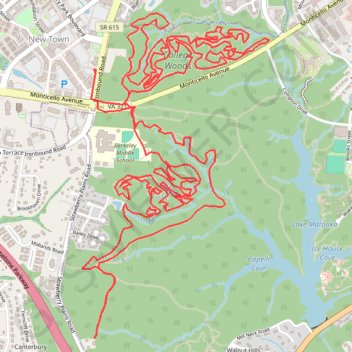
College Woods MTB Trails
- Distance: 12.4 mi
- Elevation gain: 132 m
- Maximum elevation: 41 m
- Elevation loss: 132 m
- Minimum elevation: 18 m
- Moving time: 1 h 38 m
- Moving speed: 7.6 mph
- Maximum speed: 17.5 mph
- Total time: 2 h 2 m
- Global speed: 6.1 mph
Interactive trail map
Trail profile
- Distance: 12.4 mi
- Elevation gain: 132 m
- Maximum elevation: 41 m
- Elevation loss: 132 m
- Minimum elevation: 18 m
- Moving time: 1 h 38 m
- Moving speed: 7.6 mph
- Maximum speed: 17.5 mph
- Total time: 2 h 2 m
- Global speed: 6.1 mph
About this trail
Name: College Woods MTB Trails trail, distance, elevation, map, profile, GPS track
Coordinates: 37.26273 -76.73940 37.28098 -76.72615