Thank you for supporting this site ❤️
Make a donation
Make a donation
Gear up for your next adventure:
As an Amazon Associate, this site earns from qualifying purchases at no extra cost to you.
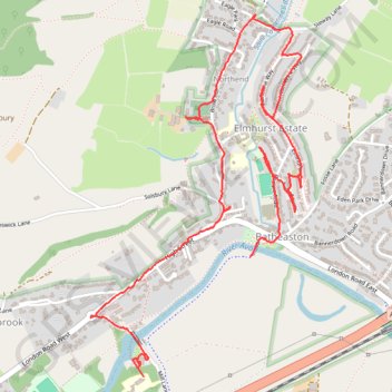
Elmhurst Batheaston
- Distance: 3.1 mi
- Elevation gain: 84 m
- Maximum elevation: 58 m
- Elevation loss: 90 m
- Minimum elevation: 20 m
- Moving time: 1 h 17 m
- Moving speed: 2.4 mph
- Maximum speed: 8.9 mph
- Total time: 1 h 24 m
- Global speed: 2.2 mph
Interactive trail map
Thank you for supporting this site ❤️
Make a donation
Make a donation
Gear up for your next adventure:
As an Amazon Associate, this site earns from qualifying purchases at no extra cost to you.
Trail profile
- Distance: 3.1 mi
- Elevation gain: 84 m
- Maximum elevation: 58 m
- Elevation loss: 90 m
- Minimum elevation: 20 m
- Moving time: 1 h 17 m
- Moving speed: 2.4 mph
- Maximum speed: 8.9 mph
- Total time: 1 h 24 m
- Global speed: 2.2 mph
Thank you for supporting this site ❤️
Make a donation
Make a donation
Gear up for your next adventure:
As an Amazon Associate, this site earns from qualifying purchases at no extra cost to you.
About this trail
Name: Elmhurst Batheaston trail, distance, elevation, map, profile, GPS track
Coordinates: 51.40003 -2.32823 51.41364 -2.31552
Topography: Bath and North East Somerset topographic map, elevation, terrain
Thank you for supporting this site ❤️
Make a donation
Make a donation
Gear up for your next adventure:
As an Amazon Associate, this site earns from qualifying purchases at no extra cost to you.