Make a donation
Gear up for your next adventure:
As an Amazon Associate, this site earns from qualifying purchases at no extra cost to you.
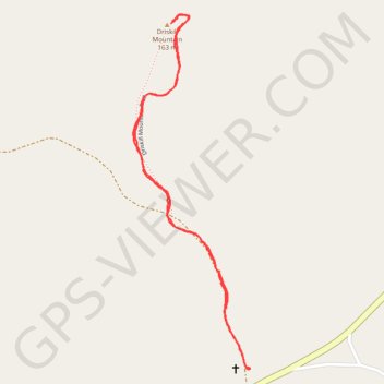
Driskill Mountain Trail in Louisiana
The Driskill Mountain Trail offers a serene hiking experience through a lush forest, leading to the highest point in Louisiana. Hikers can enjoy diverse flora, seasonal wildflowers, and the tranquility of nature while encountering various wildlife along the well-marked, wide gravel path. #Hiking #Forest #Nature
- Distance: 1.8 mi
- Elevation gain: 51 m
- Maximum elevation: 158 m
- Elevation loss: 51 m
- Minimum elevation: 125 m
- Moving time: 50 m 4 s
- Moving speed: 2.2 mph
- Maximum speed: 3.4 mph
- Total time: 1 h 7 m
- Global speed: 1.6 mph
Interactive trail map
Make a donation
Gear up for your next adventure:
As an Amazon Associate, this site earns from qualifying purchases at no extra cost to you.
Trail profile
- Distance: 1.8 mi
- Elevation gain: 51 m
- Maximum elevation: 158 m
- Elevation loss: 51 m
- Minimum elevation: 125 m
- Moving time: 50 m 4 s
- Moving speed: 2.2 mph
- Maximum speed: 3.4 mph
- Total time: 1 h 7 m
- Global speed: 1.6 mph
Make a donation
Gear up for your next adventure:
As an Amazon Associate, this site earns from qualifying purchases at no extra cost to you.
About this trail
Name: Driskill Mountain Trail in Louisiana trail, distance, elevation, map, profile, GPS track
Start: Driskill Church, LA 507, Bienville Parish, Louisiana, 71275, United States (32.41517 -92.89468)
End: 11900, LA 507, Bienville Parish, Louisiana, 71275, United States (32.41515 -92.89465)
Coordinates: 32.41512 -92.89848 32.42487 -92.89465
Make a donation
Gear up for your next adventure:
As an Amazon Associate, this site earns from qualifying purchases at no extra cost to you.