Thank you for supporting this site ❤️
Make a donation
Make a donation
Gear up for your next adventure:
As an Amazon Associate, this site earns from qualifying purchases at no extra cost to you.
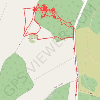
RE SK240630
- Distance: 1.5 mi
- Elevation gain: 45 m
- Maximum elevation: 307 m
- Elevation loss: 59 m
- Minimum elevation: 285 m
- Moving time: 49 m 55 s
- Moving speed: 1.8 mph
- Maximum speed: 3.3 mph
- Total time: 5 h 14 m
- Global speed: 0.3 mph
Interactive trail map
Thank you for supporting this site ❤️
Make a donation
Make a donation
Gear up for your next adventure:
As an Amazon Associate, this site earns from qualifying purchases at no extra cost to you.
Trail profile
- Distance: 1.5 mi
- Elevation gain: 45 m
- Maximum elevation: 307 m
- Elevation loss: 59 m
- Minimum elevation: 285 m
- Moving time: 49 m 55 s
- Moving speed: 1.8 mph
- Maximum speed: 3.3 mph
- Total time: 5 h 14 m
- Global speed: 0.3 mph
Thank you for supporting this site ❤️
Make a donation
Make a donation
Gear up for your next adventure:
As an Amazon Associate, this site earns from qualifying purchases at no extra cost to you.
About this trail
Name: RE SK240630 trail, distance, elevation, map, profile, GPS track
Coordinates: 53.16165 -1.64253 53.16462 -1.63963
Topography: Derbyshire Dales topographic map, elevation, terrain
Thank you for supporting this site ❤️
Make a donation
Make a donation
Gear up for your next adventure:
As an Amazon Associate, this site earns from qualifying purchases at no extra cost to you.