Thank you for supporting this site ❤️
Make a donation
Make a donation
Gear up for your next adventure:
As an Amazon Associate, this site earns from qualifying purchases at no extra cost to you.
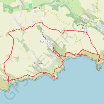
Treen - Logan Rock - Porthcurno - Rospletha Cliff - Porth Chapel - Cox Cliff - Porthgwarra
Cornwall National Landscape Loop Walk
- Distance: 7.3 mi
- Elevation gain: 393 m
- Maximum elevation: 93 m
- Elevation loss: 394 m
- Minimum elevation: 0 m
Interactive trail map
Thank you for supporting this site ❤️
Make a donation
Make a donation
Gear up for your next adventure:
As an Amazon Associate, this site earns from qualifying purchases at no extra cost to you.
Trail profile
- Distance: 7.3 mi
- Elevation gain: 393 m
- Maximum elevation: 93 m
- Elevation loss: 394 m
- Minimum elevation: 0 m
Thank you for supporting this site ❤️
Make a donation
Make a donation
Gear up for your next adventure:
As an Amazon Associate, this site earns from qualifying purchases at no extra cost to you.
About this trail
Name: Treen - Logan Rock - Porthcurno - Rospletha Cliff - Porth Chapel - Cox Cliff - Porthgwarra trail, distance, elevation, map, profile, GPS track
Coordinates: 50.03723 -5.67433 50.05264 -5.63587
Topography: Cornwall topographic map, elevation, terrain
Thank you for supporting this site ❤️
Make a donation
Make a donation
Gear up for your next adventure:
As an Amazon Associate, this site earns from qualifying purchases at no extra cost to you.