Make a donation
Gear up for your next adventure:
As an Amazon Associate, this site earns from qualifying purchases at no extra cost to you.
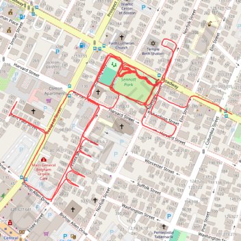
Gravel Bike Sennot Park
- Distance: 2.7 mi
- Elevation gain: 16 m
- Maximum elevation: 11 m
- Elevation loss: 17 m
- Minimum elevation: 6 m
- Moving time: 28 m 17 s
- Moving speed: 5.8 mph
- Maximum speed: 11.3 mph
- Total time: 28 m 17 s
- Global speed: 5.8 mph
Interactive trail map
Make a donation
Gear up for your next adventure:
As an Amazon Associate, this site earns from qualifying purchases at no extra cost to you.
Trail profile
- Distance: 2.7 mi
- Elevation gain: 16 m
- Maximum elevation: 11 m
- Elevation loss: 17 m
- Minimum elevation: 6 m
- Moving time: 28 m 17 s
- Moving speed: 5.8 mph
- Maximum speed: 11.3 mph
- Total time: 28 m 17 s
- Global speed: 5.8 mph
Make a donation
Gear up for your next adventure:
As an Amazon Associate, this site earns from qualifying purchases at no extra cost to you.
About this trail
Name: Gravel Bike Sennot Park trail, distance, elevation, map, profile, GPS track
Coordinates: 42.36591 -71.10350 42.36940 -71.09703
Make a donation
Gear up for your next adventure:
As an Amazon Associate, this site earns from qualifying purchases at no extra cost to you.
Other hiking, mountain biking, running and outdoor activity trails
Click on a trail to view its statistics, map and profile.
Charles River Trails in Watertown, Newton, Cambridge, Boston
United States > Massachusetts > Middlesex County > Newton
River Ride, both sides
Distance: 16.4 mi • Elevation gain: 166 m • Maximum elevation: 14 m
Nahant and Northern Strand Trail
United States > Massachusetts > Suffolk County > Boston
Distance: 43.7 mi • Elevation gain: 388 m • Maximum elevation: 23 m