Import a GPX file

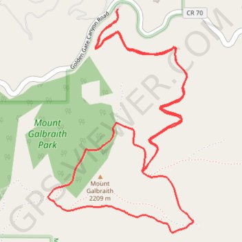
Mount Galbraith Loop

Mount Galbraith Park. #Hiking #Running #Loop #Mountain #Forest #Nature

  • Distance: 4.1 mi
  • Elevation gain: 341 m
  • Maximum elevation: 2,194 m
  • Elevation loss: 341 m
  • Minimum elevation: 1,918 m

Interactive trail map

Trail profile

  • Distance: 4.1 mi
  • Elevation gain: 341 m
  • Maximum elevation: 2,194 m
  • Elevation loss: 341 m
  • Minimum elevation: 1,918 m

About this trail

Gear up for your next adventure:

👖Packable Overtrousers - Quick-deploy rain protection for legs in sudden storms
🛑Emergency Bivvy Bags - Heat-reflective survival bags for unexpected nights out
🌂Windproof Trekking Umbrellas - Surprising but effective rain protection on low-wind trails
🔦Keychain LED Torches - Emergency backup light for finding gear in your pack
🚲Bikepacking Frame Bags - Storage for tools and navigation gear on long off-road rides

As an Amazon Associate, this site earns from qualifying purchases at no extra cost to you.