
Great Blue Hill via Skyline Loop Trail in Blue Hills Reservation
The Skyline Loop Trail in Blue Hills Reservation offers a moderately challenging hike through dense forests, leading to the summit of Great Blue Hill. Along the trail, hikers can explore the historic Eliot Observation Tower, built by the Civilian Conservation Corps during the Great Depression, which provides panoramic views of the Boston skyline and Harbor Islands. Additionally, the trail passes by the oldest continuously used weather station in North America, adding a touch of historical significance to the scenic journey. #Hiking #Loop #Forest #Overlook #Nature
- Distance: 3.1 mi
- Elevation gain: 219 m
- Maximum elevation: 189 m
- Elevation loss: 221 m
- Minimum elevation: 63 m
- Moving time: 1 h 52 m
- Moving speed: 1.7 mph
- Maximum speed: 3.4 mph
- Total time: 2 h 42 m
- Global speed: 1.1 mph
Interactive trail map
Trail profile
- Distance: 3.1 mi
- Elevation gain: 219 m
- Maximum elevation: 189 m
- Elevation loss: 221 m
- Minimum elevation: 63 m
- Moving time: 1 h 52 m
- Moving speed: 1.7 mph
- Maximum speed: 3.4 mph
- Total time: 2 h 42 m
- Global speed: 1.1 mph
About this trail
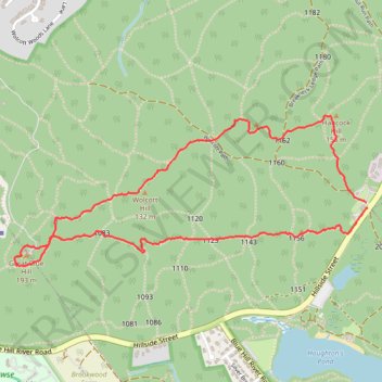
Name: Great Blue Hill via Skyline Loop Trail in Blue Hills Reservation trail, distance, elevation, map, profile, GPS track
Start: Hillside Street, Milton, Norfolk County, Massachusetts, 02186, United States (42.21421 -71.09349)
Coordinates: 42.21135 -71.11488 42.21810 -71.09342
Other hiking, mountain biking, running and outdoor activity trails
Click on a trail to view its statistics, map and profile.

Eliot Tower and Great Blue Hill Loop via Skyline Trail in Blue Hills Reservation
United States > Massachusetts > Norfolk County > Milton
The Eliot Tower and Great Blue Hill Loop offers hikers a rewarding blend of natural beauty and historical significance. As you traverse the rocky terrain, you’ll encounter stunning panoramic views of the Boston skyline and the surrounding landscape from the summit of Great Blue Hill, making it an ideal spot…
Distance: 3.3 mi • Elevation gain: 226 m • Maximum elevation: 187 m