Thank you for supporting this site ❤️
Make a donation
Make a donation
Gear up for your next adventure:
As an Amazon Associate, this site earns from qualifying purchases at no extra cost to you.
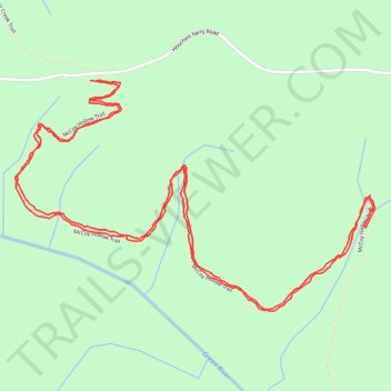
Hiking part of McCoy Hollow Trail
- Distance: 3.7 mi
- Elevation gain: 160 m
- Maximum elevation: 247 m
- Elevation loss: 160 m
- Minimum elevation: 156 m
- Moving time: 1 h 47 m
- Moving speed: 2.1 mph
- Maximum speed: 7.4 mph
- Total time: 2 h 57 m
- Global speed: 1.3 mph
Interactive trail map
Thank you for supporting this site ❤️
Make a donation
Make a donation
Gear up for your next adventure:
As an Amazon Associate, this site earns from qualifying purchases at no extra cost to you.
Trail profile
- Distance: 3.7 mi
- Elevation gain: 160 m
- Maximum elevation: 247 m
- Elevation loss: 160 m
- Minimum elevation: 156 m
- Moving time: 1 h 47 m
- Moving speed: 2.1 mph
- Maximum speed: 7.4 mph
- Total time: 2 h 57 m
- Global speed: 1.3 mph
Thank you for supporting this site ❤️
Make a donation
Make a donation
Gear up for your next adventure:
As an Amazon Associate, this site earns from qualifying purchases at no extra cost to you.
About this trail
Name: Hiking part of McCoy Hollow Trail trail, distance, elevation, map, profile, GPS track
Start: Houchins Ferry Road, Edmonson County, Kentucky, 42259, United States (37.21864 -86.22264)
End: McCoy Hollow Trail, Edmonson County, Kentucky, United States (37.21861 -86.22244)
Coordinates: 37.21205 -86.22536 37.21866 -86.21239
Thank you for supporting this site ❤️
Make a donation
Make a donation
Gear up for your next adventure:
As an Amazon Associate, this site earns from qualifying purchases at no extra cost to you.