Living Room Trail in Uinta-Wasatch-Cache National Forest
The Living Room Trail in the Uinta-Wasatch-Cache National Forest is a popular hike that leads to a stunning viewpoint overlooking the Salt Lake Valley. Along the route, hikers will pass through scenic open meadows and rocky outcrops. Upon reaching the summit, visitors are rewarded with panoramic views of the city below, the Salt Lake Valley, the Great Salt Lake, and the Oquirrh Mountains, all while relaxing on sandstone slabs creatively arranged as "furniture." This unique vantage point provides a comfortable and scenic spot to appreciate Utah's diverse landscapes. #Hiking #Mountain #City #Overlook #Nature
- Distance: 2.4 mi
- Elevation gain: 317 m
- Maximum elevation: 1,837 m
- Elevation loss: 316 m
- Minimum elevation: 1,526 m
- Moving time: 58 m 37 s
- Moving speed: 2.4 mph
- Maximum speed: 3.5 mph
- Total time: 1 h 13 m
- Global speed: 1.9 mph
Interactive trail map
Trail profile
- Distance: 2.4 mi
- Elevation gain: 317 m
- Maximum elevation: 1,837 m
- Elevation loss: 316 m
- Minimum elevation: 1,526 m
- Moving time: 58 m 37 s
- Moving speed: 2.4 mph
- Maximum speed: 3.5 mph
- Total time: 1 h 13 m
- Global speed: 1.9 mph
About this trail
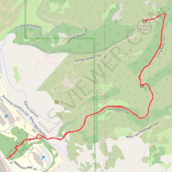
Name: Living Room Trail in Uinta-Wasatch-Cache National Forest trail, distance, elevation, map, profile, GPS track
Coordinates: 40.75935 -111.82133 40.76702 -111.81021
Other hiking, mountain biking, running and outdoor activity trails
Click on a trail to view its statistics, map and profile.