Make a donation
Gear up for your next adventure:
As an Amazon Associate, this site earns from qualifying purchases at no extra cost to you.
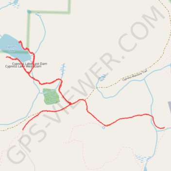
Cypress Lake (Cypress Island)
Hike to Cypress Lake via Cypress Island Trail in the Cypress Highlands Natural Area Preserve. #Hiking #Lake #Island #Nature #Forest
- Distance: 3.0 mi
- Elevation gain: 159 m
- Maximum elevation: 338 m
- Elevation loss: 158 m
- Minimum elevation: 251 m
- Moving time: 1 h 8 m
- Moving speed: 2.7 mph
- Maximum speed: 5.3 mph
- Total time: 1 h 23 m
- Global speed: 2.2 mph
Interactive trail map
Make a donation
Gear up for your next adventure:
As an Amazon Associate, this site earns from qualifying purchases at no extra cost to you.
Trail profile
- Distance: 3.0 mi
- Elevation gain: 159 m
- Maximum elevation: 338 m
- Elevation loss: 158 m
- Minimum elevation: 251 m
- Moving time: 1 h 8 m
- Moving speed: 2.7 mph
- Maximum speed: 5.3 mph
- Total time: 1 h 23 m
- Global speed: 2.2 mph
Make a donation
Gear up for your next adventure:
As an Amazon Associate, this site earns from qualifying purchases at no extra cost to you.
About this trail
Name: Cypress Lake (Cypress Island) trail, distance, elevation, map, profile, GPS track
Start: Cypress Mainline Trail, Skagit County, Washington, United States (48.57234 -122.71096)
End: Old Airfield Trail, Skagit County, Washington, United States (48.57257 -122.69219)
Coordinates: 48.57234 -122.71314 48.58015 -122.69219
Make a donation
Gear up for your next adventure:
As an Amazon Associate, this site earns from qualifying purchases at no extra cost to you.