Thank you for supporting this site ❤️
Make a donation
Make a donation
Gear up for your next adventure:
As an Amazon Associate, this site earns from qualifying purchases at no extra cost to you.
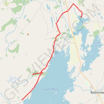
Lough Mask - Ballintober Abbey - Lough Carra
#Bike
- Distance: 32.1 mi
- Elevation gain: 387 m
- Maximum elevation: 60 m
- Elevation loss: 378 m
- Minimum elevation: 18 m
Interactive trail map
Thank you for supporting this site ❤️
Make a donation
Make a donation
Gear up for your next adventure:
As an Amazon Associate, this site earns from qualifying purchases at no extra cost to you.
Trail profile
- Distance: 32.1 mi
- Elevation gain: 387 m
- Maximum elevation: 60 m
- Elevation loss: 378 m
- Minimum elevation: 18 m
Thank you for supporting this site ❤️
Make a donation
Make a donation
Gear up for your next adventure:
As an Amazon Associate, this site earns from qualifying purchases at no extra cost to you.
About this trail
Name: Lough Mask - Ballintober Abbey - Lough Carra trail, distance, elevation, map, profile, GPS track
Coordinates: 53.61226 -9.41713 53.75849 -9.26206
Thank you for supporting this site ❤️
Make a donation
Make a donation
Gear up for your next adventure:
As an Amazon Associate, this site earns from qualifying purchases at no extra cost to you.
Other hiking, mountain biking, running and outdoor activity trails
Click on a trail to view its statistics, map and profile.
Connemara - Day 3
#Bike
Distance: 38.8 mi • Elevation gain: 861 m • Maximum elevation: 291 m