Thank you for supporting this site ❤️
Make a donation
Make a donation
Gear up for your next adventure:
As an Amazon Associate, this site earns from qualifying purchases at no extra cost to you.
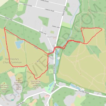
The Devil's Jumps Loop
Loop hike to Stony Jump, The Devil's Jumps via Axe Pond in the Flashes, Churt Common and Hankley Common. #Hiking #Loop #Nature #Forest
- Distance: 3.2 mi
- Elevation gain: 91 m
- Maximum elevation: 108 m
- Elevation loss: 94 m
- Minimum elevation: 56 m
- Moving time: 1 h 16 m
- Moving speed: 2.5 mph
- Maximum speed: 9.3 mph
- Total time: 1 h 24 m
- Global speed: 2.2 mph
Interactive trail map
Thank you for supporting this site ❤️
Make a donation
Make a donation
Gear up for your next adventure:
As an Amazon Associate, this site earns from qualifying purchases at no extra cost to you.
Trail profile
- Distance: 3.2 mi
- Elevation gain: 91 m
- Maximum elevation: 108 m
- Elevation loss: 94 m
- Minimum elevation: 56 m
- Moving time: 1 h 16 m
- Moving speed: 2.5 mph
- Maximum speed: 9.3 mph
- Total time: 1 h 24 m
- Global speed: 2.2 mph
Thank you for supporting this site ❤️
Make a donation
Make a donation
Gear up for your next adventure:
As an Amazon Associate, this site earns from qualifying purchases at no extra cost to you.
About this trail
Name: The Devil's Jumps Loop trail, distance, elevation, map, profile, GPS track
Coordinates: 51.14867 -0.76597 51.15625 -0.74312
Topography: Waverley topographic map, elevation, terrain
Thank you for supporting this site ❤️
Make a donation
Make a donation
Gear up for your next adventure:
As an Amazon Associate, this site earns from qualifying purchases at no extra cost to you.