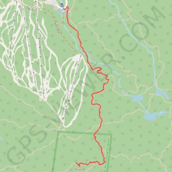
Round Top - Sutton Trail
https://en-hk.gps-viewer.com/track-hk4mt/Round-Top-Sutton-Trail/
- Distance: 3.8 mi
- Elevation gain: 422 m
- Maximum elevation: 944 m
- Elevation loss: 422 m
- Minimum elevation: 521 m
Interactive trail map
Trail profile
- Distance: 3.8 mi
- Elevation gain: 422 m
- Maximum elevation: 944 m
- Elevation loss: 422 m
- Minimum elevation: 521 m
About this trail
Name: Round Top - Sutton Trail trail, distance, elevation, map, profile, GPS track
Start: 582, Chemin Réal, Sutton, Brome-Missisquoi, Quebec, Canada (45.09695 -72.54884)
End: 582, Chemin Réal, Sutton, Brome-Missisquoi, Quebec, Canada (45.09695 -72.54884)
Coordinates: 45.08089 -72.54884 45.09712 -72.54227
Other hiking, mountain biking, running and outdoor activity trails
Click on a trail to view its statistics, map and profile.
Round Top - Sutton Trail
Canada > Quebec > Brome-Missisquoi > Sutton
Sutton Natural Environment Park. #Hiking #Snowshoeing #Sutton
Distance: 3.8 mi • Elevation gain: 422 m • Maximum elevation: 944 m
Round Top and Spruce Lake Loop
Canada > Quebec > Brome-Missisquoi > Sutton
Sutton Natural Environment Park. #Hiking #Snowshoeing #Loop #Sutton
Distance: 4.4 mi • Elevation gain: 428 m • Maximum elevation: 944 m