Make a donation
Gear up for your next adventure:
As an Amazon Associate, this site earns from qualifying purchases at no extra cost to you.
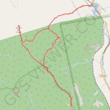
Mount Field, Mount Willey, Mount Avalon and Mount Tom Loop
Loop hike from Sako Lake via Avalon Trail, Mount Avalon, Mount Field, Willey Range Trail, Mount Willey, Mount Tom Spur, Mount Tom and A-Z Trail in the White Mountain National Forest. #Hiking #Loop #Mountain #Nature #Forest #Lake
- Distance: 9.4 mi
- Elevation gain: 1,021 m
- Maximum elevation: 1,299 m
- Elevation loss: 1,021 m
- Minimum elevation: 575 m
- Moving time: 4 h 41 m
- Moving speed: 2.0 mph
- Maximum speed: 3.2 mph
- Total time: 5 h 33 m
- Global speed: 1.7 mph
Interactive trail map
Make a donation
Gear up for your next adventure:
As an Amazon Associate, this site earns from qualifying purchases at no extra cost to you.
Trail profile
- Distance: 9.4 mi
- Elevation gain: 1,021 m
- Maximum elevation: 1,299 m
- Elevation loss: 1,021 m
- Minimum elevation: 575 m
- Moving time: 4 h 41 m
- Moving speed: 2.0 mph
- Maximum speed: 3.2 mph
- Total time: 5 h 33 m
- Global speed: 1.7 mph
Make a donation
Gear up for your next adventure:
As an Amazon Associate, this site earns from qualifying purchases at no extra cost to you.
About this trail
Name: Mount Field, Mount Willey, Mount Avalon and Mount Tom Loop trail, distance, elevation, map, profile, GPS track
Start: Crawford, Avalon Trail, Carroll, Coös County, New Hampshire, United States (44.21778 -71.41122)
End: Crawford, Avalon Trail, Carroll, Coös County, New Hampshire, United States (44.21771 -71.41122)
Coordinates: 44.18331 -71.44647 44.21778 -71.41122
Make a donation
Gear up for your next adventure:
As an Amazon Associate, this site earns from qualifying purchases at no extra cost to you.
Other hiking, mountain biking, running and outdoor activity trails
Click on a trail to view its statistics, map and profile.
Mount Willard Trail in White Mountain National Forest
United States > New Hampshire > Coos County > Carroll
The Mount Willard Trail provides an accessible yet rewarding hike with exceptional views. As you ascend, you pass through a fragrant forest, encountering small waterfalls and serene pools before reaching a rocky, steeper section that leads to the summit. At the top, the panoramic vista of Crawford Notch and…
Distance: 3.2 mi • Elevation gain: 301 m • Maximum elevation: 849 m