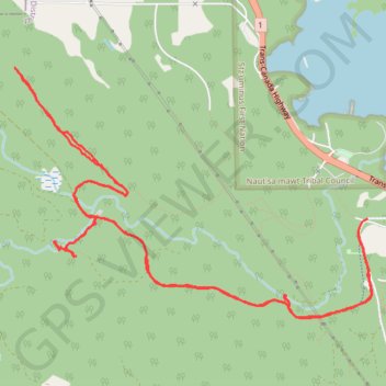
Christie Falls - Camas Ridge
- Distance: 7.8 mi
- Elevation gain: 270 m
- Maximum elevation: 164 m
- Elevation loss: 271 m
- Minimum elevation: 23 m
Interactive trail map
Trail profile
- Distance: 7.8 mi
- Elevation gain: 270 m
- Maximum elevation: 164 m
- Elevation loss: 271 m
- Minimum elevation: 23 m
About this trail
Name: Christie Falls - Camas Ridge trail, distance, elevation, map, profile, GPS track
Coordinates: 49.00430 -123.88643 49.02138 -123.84924
Other hiking, mountain biking, running and outdoor activity trails
Click on a trail to view its statistics, map and profile.
BBF loop to the Skydeck in Nanaimo
Canada > British Columbia > Cowichan Valley Regional District > Area A (Mill Bay / Malahat) > Mill Bay
BBF loop to the Skydeck
Distance: 201.0 mi • Elevation gain: 6,222 m • Maximum elevation: 706 m