Vurnje Ivicin Skok
- Distance: 17.3 mi
- Elevation gain: 1,417 m
- Maximum elevation: 1,595 m
- Elevation loss: 1,412 m
- Minimum elevation: 726 m
- Moving time: 7 h 6 m
- Moving speed: 2.4 mph
- Maximum speed: 4.3 mph
- Total time: 11 h 52 m
- Global speed: 1.5 mph
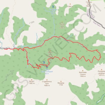
Interactive trail map
Trail profile
- Distance: 17.3 mi
- Elevation gain: 1,417 m
- Maximum elevation: 1,595 m
- Elevation loss: 1,412 m
- Minimum elevation: 726 m
- Moving time: 7 h 6 m
- Moving speed: 2.4 mph
- Maximum speed: 4.3 mph
- Total time: 11 h 52 m
- Global speed: 1.5 mph
About this trail
Name: Vurnje Ivicin Skok trail, distance, elevation, map, profile, GPS track
Coordinates: 43.32464 22.68001 43.34923 22.78098
Other hiking, mountain biking, running and outdoor activity trails
Click on a trail to view its statistics, map and profile.
Stara planina: vodopadi Vurnje (Vurnja, Zuberski skok, Zuber...
Serbia > Central Serbia > Pirot Administrative District > Topli Do
Distance: 12.6 mi • Elevation gain: 933 m • Maximum elevation: 1,379 m
STARA PLANINA: Topli Do - BABIN ZUB (1.758) - DUPLJAK (2.032...
Serbia > Central Serbia > Pirot Administrative District > Topli Do
Distance: 21.3 mi • Elevation gain: 2,173 m • Maximum elevation: 2,159 m