Import a GPX file

Redcliffe Plantation State Historic Site

  • Distance: 2.1 mi
  • Elevation gain: 30 m
  • Maximum elevation: 127 m
  • Elevation loss: 39 m
  • Minimum elevation: 95 m
  • Moving time: 1 h 4 m
  • Moving speed: 1.9 mph
  • Maximum speed: 7.8 mph
  • Total time: 1 h 31 m
  • Global speed: 1.3 mph

Interactive trail map

Trail profile

  • Distance: 2.1 mi
  • Elevation gain: 30 m
  • Maximum elevation: 127 m
  • Elevation loss: 39 m
  • Minimum elevation: 95 m
  • Moving time: 1 h 4 m
  • Moving speed: 1.9 mph
  • Maximum speed: 7.8 mph
  • Total time: 1 h 31 m
  • Global speed: 1.3 mph

About this trail
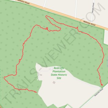
Name: Redcliffe Plantation State Historic Site trail, distance, elevation, map, profile, GPS track

Start: Redcliffe Plantation Trail, Beech Island, Aiken County, South Carolina, 29842, United States (33.41795 -81.86286)

End: Redcliffe Plantation Trail, Beech Island, Aiken County, South Carolina, 29842, United States (33.41728 -81.87036)

Coordinates: 33.41726 -81.87415 33.42469 -81.86257

Gear up for your next adventure:

🌂Windproof Trekking Umbrellas - Surprising but effective rain protection on low-wind trails
🥤Collapsible Water Bottles - Save space in your rucksack as you consume your water
🛌Insulated Sleeping Mats - Crucial thermal protection when sleeping on cold, uneven ground
🦯Walking Poles - Supportive poles for long-distance walking
🚲Cycling GPS Computers - Track elevation and topographic routes on two wheels

As an Amazon Associate, this site earns from qualifying purchases at no extra cost to you.