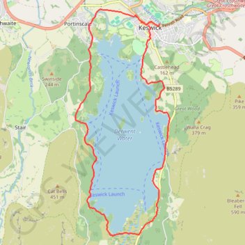
Derwent Water Loop
- Distance: 9.3 mi
- Elevation gain: 196 m
- Maximum elevation: 117 m
- Elevation loss: 201 m
- Minimum elevation: 75 m
- Moving time: 3 h 50 m
- Moving speed: 2.4 mph
- Maximum speed: 3.3 mph
- Total time: 4 h 19 m
- Global speed: 2.1 mph
Interactive trail map
Trail profile
- Distance: 9.3 mi
- Elevation gain: 196 m
- Maximum elevation: 117 m
- Elevation loss: 201 m
- Minimum elevation: 75 m
- Moving time: 3 h 50 m
- Moving speed: 2.4 mph
- Maximum speed: 3.3 mph
- Total time: 4 h 19 m
- Global speed: 2.1 mph
About this trail
Name: Derwent Water Loop trail, distance, elevation, map, profile, GPS track
Coordinates: 54.55800 -3.16418 54.60479 -3.13058
Topography: Cumberland topographic map, elevation, terrain
Other hiking, mountain biking, running and outdoor activity trails
Click on a trail to view its statistics, map and profile.
Latrigg Loop
United Kingdom > England > Cumberland > Keswick > Old Windlebrowe
Distance: 5.4 mi • Elevation gain: 252 m • Maximum elevation: 308 m