Koala Park Bushland Conservation Reserve
- Distance: 1.4 mi
- Elevation gain: 123 m
- Maximum elevation: 127 m
- Elevation loss: 137 m
- Minimum elevation: 45 m
- Moving time: 42 m 18 s
- Moving speed: 1.9 mph
- Maximum speed: 4.6 mph
- Total time: 44 m 32 s
- Global speed: 1.8 mph
Interactive trail map
Trail profile
- Distance: 1.4 mi
- Elevation gain: 123 m
- Maximum elevation: 127 m
- Elevation loss: 137 m
- Minimum elevation: 45 m
- Moving time: 42 m 18 s
- Moving speed: 1.9 mph
- Maximum speed: 4.6 mph
- Total time: 44 m 32 s
- Global speed: 1.8 mph
About this trail
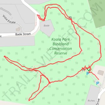
Name: Koala Park Bushland Conservation Reserve trail, distance, elevation, map, profile, GPS track
Coordinates: -26.63046 152.96777 -26.62687 152.97182
Other hiking, mountain biking, running and outdoor activity trails
Click on a trail to view its statistics, map and profile.
Imbil Jimna Kenilworth loop
Australia > Queensland > Tewantin
Distance: 134.2 mi • Elevation gain: 3,884 m • Maximum elevation: 822 m