Thank you for supporting this site ❤️
Make a donation
Make a donation
Gear up for your next adventure:
As an Amazon Associate, this site earns from qualifying purchases at no extra cost to you.
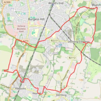
Walk - Ditchling Common, Burgess Hill, Hassocks, Keymer
- Distance: 11.6 mi
- Elevation gain: 154 m
- Maximum elevation: 73 m
- Elevation loss: 153 m
- Minimum elevation: 28 m
- Moving time: 4 h 4 m
- Moving speed: 2.8 mph
- Maximum speed: 5.3 mph
- Total time: 5 h 29 m
- Global speed: 2.1 mph
Interactive trail map
Thank you for supporting this site ❤️
Make a donation
Make a donation
Gear up for your next adventure:
As an Amazon Associate, this site earns from qualifying purchases at no extra cost to you.
Trail profile
- Distance: 11.6 mi
- Elevation gain: 154 m
- Maximum elevation: 73 m
- Elevation loss: 153 m
- Minimum elevation: 28 m
- Moving time: 4 h 4 m
- Moving speed: 2.8 mph
- Maximum speed: 5.3 mph
- Total time: 5 h 29 m
- Global speed: 2.1 mph
Thank you for supporting this site ❤️
Make a donation
Make a donation
Gear up for your next adventure:
As an Amazon Associate, this site earns from qualifying purchases at no extra cost to you.
About this trail
Name: Walk - Ditchling Common, Burgess Hill, Hassocks, Keymer trail, distance, elevation, map, profile, GPS track
Coordinates: 50.92150 -0.15790 50.96339 -0.08691
Topography: East Sussex topographic map, elevation, terrain
Thank you for supporting this site ❤️
Make a donation
Make a donation
Gear up for your next adventure:
As an Amazon Associate, this site earns from qualifying purchases at no extra cost to you.