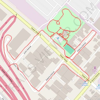
Griffith Manor Park
- Distance: 1.3 mi
- Elevation gain: 6 m
- Maximum elevation: 152 m
- Elevation loss: 6 m
- Minimum elevation: 147 m
- Moving time: 25 m 29 s
- Moving speed: 3.0 mph
- Maximum speed: 5.3 mph
- Total time: 29 m 54 s
- Global speed: 2.5 mph
Interactive trail map
Trail profile
- Distance: 1.3 mi
- Elevation gain: 6 m
- Maximum elevation: 152 m
- Elevation loss: 6 m
- Minimum elevation: 147 m
- Moving time: 25 m 29 s
- Moving speed: 3.0 mph
- Maximum speed: 5.3 mph
- Total time: 29 m 54 s
- Global speed: 2.5 mph
About this trail
Name: Griffith Manor Park trail, distance, elevation, map, profile, GPS track
Start: Flower Street, Glendale, Los Angeles County, California, 91201, United States (34.16425 -118.29247)
End: Flower Street, Glendale, Los Angeles County, California, 91201, United States (34.16429 -118.29244)
Coordinates: 34.16269 -118.29466 34.16520 -118.29126