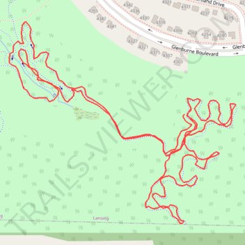
Lansing West Lansing Trail Ryan's Loop
- Distance: 1.9 mi
- Elevation gain: 10 m
- Maximum elevation: 266 m
- Elevation loss: 10 m
- Minimum elevation: 259 m
- Moving time: 19 m 43 s
- Moving speed: 5.7 mph
- Maximum speed: 16.8 mph
- Total time: 19 m 43 s
- Global speed: 5.7 mph
Interactive trail map
Trail profile
- Distance: 1.9 mi
- Elevation gain: 10 m
- Maximum elevation: 266 m
- Elevation loss: 10 m
- Minimum elevation: 259 m
- Moving time: 19 m 43 s
- Moving speed: 5.7 mph
- Maximum speed: 16.8 mph
- Total time: 19 m 43 s
- Global speed: 5.7 mph
About this trail
Name: Lansing West Lansing Trail Ryan's Loop trail, distance, elevation, map, profile, GPS track
Coordinates: 42.68554 -84.61857 42.68923 -84.61293
Other hiking, mountain biking, running and outdoor activity trails
Click on a trail to view its statistics, map and profile.
Theo Fulton Park, Hunters Ridge Park and Fine Park loop along Grand River
United States > Michigan > Eaton County > Lansing
Distance: 7.8 mi • Elevation gain: 71 m • Maximum elevation: 269 m
West Lansing Trail Ryan's Loop
United States > Michigan > Eaton County > Lansing
Distance: 1.1 mi • Elevation gain: 1 m • Maximum elevation: 266 m