Thank you for supporting this site ❤️
Make a donation
Make a donation
Gear up for your next adventure:
As an Amazon Associate, this site earns from qualifying purchases at no extra cost to you.
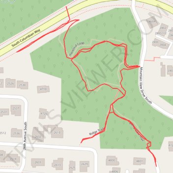
Cheasty Greenspace trails and links south of Columbian Way
- Distance: 0.7 mi
- Elevation gain: 34 m
- Maximum elevation: 98 m
- Elevation loss: 36 m
- Minimum elevation: 71 m
- Moving time: 18 m 38 s
- Moving speed: 2.3 mph
- Maximum speed: 6.3 mph
- Total time: 23 m 32 s
- Global speed: 1.8 mph
Interactive trail map
Thank you for supporting this site ❤️
Make a donation
Make a donation
Gear up for your next adventure:
As an Amazon Associate, this site earns from qualifying purchases at no extra cost to you.
Trail profile
- Distance: 0.7 mi
- Elevation gain: 34 m
- Maximum elevation: 98 m
- Elevation loss: 36 m
- Minimum elevation: 71 m
- Moving time: 18 m 38 s
- Moving speed: 2.3 mph
- Maximum speed: 6.3 mph
- Total time: 23 m 32 s
- Global speed: 1.8 mph
Thank you for supporting this site ❤️
Make a donation
Make a donation
Gear up for your next adventure:
As an Amazon Associate, this site earns from qualifying purchases at no extra cost to you.
About this trail
Name: Cheasty Greenspace trails and links south of Columbian Way trail, distance, elevation, map, profile, GPS track
Coordinates: 47.55951 -122.29949 47.56154 -122.29686
Thank you for supporting this site ❤️
Make a donation
Make a donation
Gear up for your next adventure:
As an Amazon Associate, this site earns from qualifying purchases at no extra cost to you.