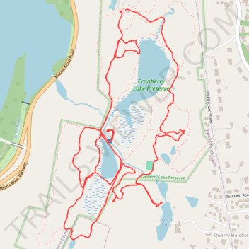
Cranberry Lake Preserve
- Distance: 3.3 mi
- Elevation gain: 107 m
- Maximum elevation: 142 m
- Elevation loss: 106 m
- Minimum elevation: 115 m
- Moving time: 1 h 8 m
- Moving speed: 2.9 mph
- Maximum speed: 6.0 mph
- Total time: 1 h 40 m
- Global speed: 2.0 mph
Interactive trail map
Trail profile
- Distance: 3.3 mi
- Elevation gain: 107 m
- Maximum elevation: 142 m
- Elevation loss: 106 m
- Minimum elevation: 115 m
- Moving time: 1 h 8 m
- Moving speed: 2.9 mph
- Maximum speed: 6.0 mph
- Total time: 1 h 40 m
- Global speed: 2.0 mph
About this trail
Name: Cranberry Lake Preserve trail, distance, elevation, map, profile, GPS track
Coordinates: 41.06907 -73.75984 41.07830 -73.75344
Other hiking, mountain biking, running and outdoor activity trails
Click on a trail to view its statistics, map and profile.