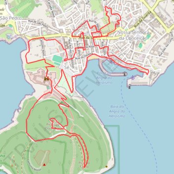
AbN25
- Distance: 6.8 mi
- Elevation gain: 364 m
- Maximum elevation: 192 m
- Elevation loss: 364 m
- Minimum elevation: -2 m
- Moving time: 1 h 8 m
- Moving speed: 5.9 mph
- Maximum speed: 11.3 mph
- Total time: 1 h 8 m
- Global speed: 5.9 mph
Interactive trail map
Trail profile
- Distance: 6.8 mi
- Elevation gain: 364 m
- Maximum elevation: 192 m
- Elevation loss: 364 m
- Minimum elevation: -2 m
- Moving time: 1 h 8 m
- Moving speed: 5.9 mph
- Maximum speed: 11.3 mph
- Total time: 1 h 8 m
- Global speed: 5.9 mph
About this trail
Name: AbN25 trail, distance, elevation, map, profile, GPS track
End: Rua do Marquês, Angra (Sé), Angra do Heroísmo, Azores, 9700-201, Portugal (38.65588 -27.21891)
Coordinates: 38.64240 -27.22894 38.65900 -27.21272