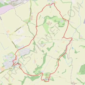
Mickleton Trailrun
- Distance: 7.4 mi
- Elevation gain: 190 m
- Maximum elevation: 199 m
- Elevation loss: 190 m
- Minimum elevation: 69 m
- Moving time: 1 h 11 m
- Moving speed: 6.2 mph
- Maximum speed: 10.0 mph
- Total time: 1 h 11 m
- Global speed: 6.2 mph
Interactive trail map
Trail profile
- Distance: 7.4 mi
- Elevation gain: 190 m
- Maximum elevation: 199 m
- Elevation loss: 190 m
- Minimum elevation: 69 m
- Moving time: 1 h 11 m
- Moving speed: 6.2 mph
- Maximum speed: 10.0 mph
- Total time: 1 h 11 m
- Global speed: 6.2 mph
About this trail
Name: Mickleton Trailrun trail, distance, elevation, map, profile, GPS track
Coordinates: 52.08178 -1.76857 52.11455 -1.72846
Topography: Cotswold District topographic map, elevation, terrain
Other hiking, mountain biking, running and outdoor activity trails
Click on a trail to view its statistics, map and profile.
Mickleton Hills
United Kingdom > England > Gloucestershire > Cotswold District > Mickleton
Distance: 13.7 mi • Elevation gain: 468 m • Maximum elevation: 262 m