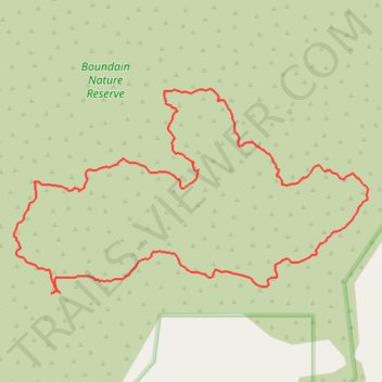
Boundain Nature Reserve Loop Walk
- Distance: 2.0 mi
- Elevation gain: 37 m
- Maximum elevation: 389 m
- Elevation loss: 37 m
- Minimum elevation: 370 m
- Moving time: 1 h 9 m
- Moving speed: 1.8 mph
- Maximum speed: 3.4 mph
- Total time: 2 h 10 m
- Global speed: 0.9 mph
Interactive trail map
Trail profile
- Distance: 2.0 mi
- Elevation gain: 37 m
- Maximum elevation: 389 m
- Elevation loss: 37 m
- Minimum elevation: 370 m
- Moving time: 1 h 9 m
- Moving speed: 1.8 mph
- Maximum speed: 3.4 mph
- Total time: 2 h 10 m
- Global speed: 0.9 mph
About this trail
Name: Boundain Nature Reserve Loop Walk trail, distance, elevation, map, profile, GPS track
Start: Boundain, Shire Of Narrogin, Western Australia, 6312, Australia (-32.92726 117.35466)
End: Boundain, Shire Of Narrogin, Western Australia, 6312, Australia (-32.92726 117.35463)
Coordinates: -32.93020 117.34941 -32.92533 117.35946