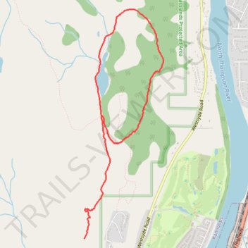
Lac du Bois - Deep Lake Loop Trail
- Distance: 3.6 mi
- Elevation gain: 251 m
- Maximum elevation: 584 m
- Elevation loss: 155 m
- Minimum elevation: 478 m
- Moving time: 1 h 48 m
- Moving speed: 2.0 mph
- Maximum speed: 4.6 mph
- Total time: 1 h 50 m
- Global speed: 1.9 mph
Interactive trail map
Trail profile
- Distance: 3.6 mi
- Elevation gain: 251 m
- Maximum elevation: 584 m
- Elevation loss: 155 m
- Minimum elevation: 478 m
- Moving time: 1 h 48 m
- Moving speed: 2.0 mph
- Maximum speed: 4.6 mph
- Total time: 1 h 50 m
- Global speed: 1.9 mph
About this trail
Name: Lac du Bois - Deep Lake Loop Trail trail, distance, elevation, map, profile, GPS track
Coordinates: 50.77824 -120.34923 50.80297 -120.33567
Other hiking, mountain biking, running and outdoor activity trails
Click on a trail to view its statistics, map and profile.
Cache Creek - Kamloops
Canada > British Columbia > Thompson-Nicola Regional District > Cache Creek
Distance: 54.0 mi • Elevation gain: 1,114 m • Maximum elevation: 736 m
Lac du Bois - Grasslands Community Trail
Canada > British Columbia > Thompson-Nicola Regional District > Kamloops
Distance: 8.1 mi • Elevation gain: 763 m • Maximum elevation: 1,013 m
Route
Canada > British Columbia > Thompson-Nicola Regional District > Area J (Copper Desert Country)
Distance: 7.0 mi • Elevation gain: 143 m • Maximum elevation: 1,008 m
Route
Canada > British Columbia > Thompson-Nicola Regional District > Kamloops
Distance: 1.9 mi • Elevation gain: 159 m • Maximum elevation: 583 m