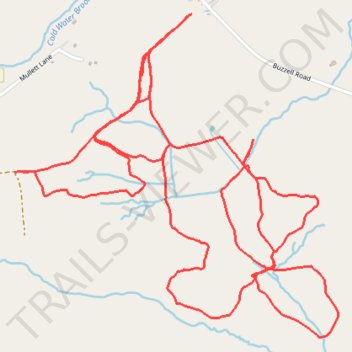
Harris Farms Cross Country Ski
- Distance: 5.5 mi
- Elevation gain: 104 m
- Maximum elevation: 67 m
- Elevation loss: 104 m
- Minimum elevation: 39 m
- Moving time: 1 h 24 m
- Moving speed: 3.9 mph
- Maximum speed: 15.1 mph
- Total time: 1 h 35 m
- Global speed: 3.5 mph
Interactive trail map
Trail profile
- Distance: 5.5 mi
- Elevation gain: 104 m
- Maximum elevation: 67 m
- Elevation loss: 104 m
- Minimum elevation: 39 m
- Moving time: 1 h 24 m
- Moving speed: 3.9 mph
- Maximum speed: 15.1 mph
- Total time: 1 h 35 m
- Global speed: 3.5 mph
About this trail
Name: Harris Farms Cross Country Ski trail, distance, elevation, map, profile, GPS track
Start: Buzzell Road, Dayton, York County, Maine, 04005, United States (43.52797 -70.57516)
End: Buzzell Road, Dayton, York County, Maine, 04005, United States (43.52809 -70.57491)
Coordinates: 43.51613 -70.58401 43.52809 -70.56743