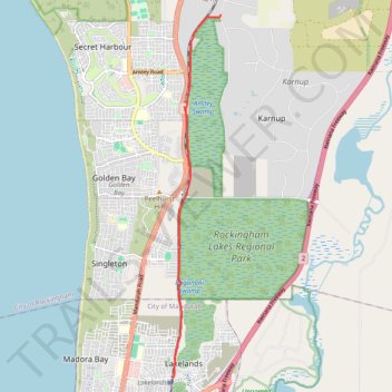
Rail Trail at Paganoni Swamp Reserve
- Distance: 5.8 mi
- Elevation gain: 64 m
- Maximum elevation: 22 m
- Elevation loss: 60 m
- Minimum elevation: 2 m
- Moving time: 28 m 52 s
- Moving speed: 12.1 mph
- Maximum speed: 26.7 mph
- Total time: 28 m 52 s
- Global speed: 12.1 mph
Interactive trail map
Trail profile
- Distance: 5.8 mi
- Elevation gain: 64 m
- Maximum elevation: 22 m
- Elevation loss: 60 m
- Minimum elevation: 2 m
- Moving time: 28 m 52 s
- Moving speed: 12.1 mph
- Maximum speed: 26.7 mph
- Total time: 28 m 52 s
- Global speed: 12.1 mph
About this trail
Name: Rail Trail at Paganoni Swamp Reserve trail, distance, elevation, map, profile, GPS track
Start: Fletcher Road, Karnup, City of Rockingham, Western Australia, 6176, Australia (-32.39401 115.78314)
Coordinates: -32.47257 115.77053 -32.39401 115.78314