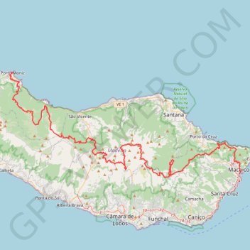
MIUT2020_115_training
- Distance: 74.2 mi
- Elevation gain: 10,113 m
- Maximum elevation: 1,797 m
- Elevation loss: 10,113 m
- Minimum elevation: 1 m
- Moving time: 1 d 4 h
- Moving speed: 2.6 mph
- Maximum speed: 5.0 mph
- Total time: 1 d 5 h
- Global speed: 2.6 mph
Interactive trail map
Trail profile
- Distance: 74.2 mi
- Elevation gain: 10,113 m
- Maximum elevation: 1,797 m
- Elevation loss: 10,113 m
- Minimum elevation: 1 m
- Moving time: 1 d 4 h
- Moving speed: 2.6 mph
- Maximum speed: 5.0 mph
- Total time: 1 d 5 h
- Global speed: 2.6 mph
About this trail
Name: MIUT2020_115_training trail, distance, elevation, map, profile, GPS track
Start: Rua Engenheiro Américo, Ladeira, Porto Moniz, Madeira, 9270-095, Portugal (32.86766 -17.16879)
Coordinates: 32.71079 -17.17179 32.86766 -16.76181
Other hiking, mountain biking, running and outdoor activity trails
Click on a trail to view its statistics, map and profile.
Santana - Le pico Ruivo depuis Achada do Teixeira
Distance: 3.9 mi • Elevation gain: 503 m • Maximum elevation: 1,837 m
Levada do Norte
Distance: 9.0 mi • Elevation gain: 980 m • Maximum elevation: 1,605 m
MIUT2020_115_training
Distance: 74.2 mi • Elevation gain: 10,113 m • Maximum elevation: 1,797 m
PR1
Portugal > Santana > São Roque do Faial
Distance: 3.5 mi • Elevation gain: 788 m • Maximum elevation: 1,836 m
MIUT2023_115_training
Distance: 69.7 mi • Elevation gain: 9,384 m • Maximum elevation: 1,797 m
Vereda do Larano and Levada do Caniçal
Distance: 7.8 mi • Elevation gain: 958 m • Maximum elevation: 413 m
Passeio aniversario nsr
Route created on plotaroute.com
Distance: 36.8 mi • Elevation gain: 3,095 m • Maximum elevation: 1,089 m
Madeira - PR 14 Levada dos Cedros - Steige unterhalb der ER ...
Portugal > Porto Moniz > Seixal
Distance: 7.1 mi • Elevation gain: 807 m • Maximum elevation: 1,158 m