Thank you for supporting this site ❤️
Make a donation
Make a donation
Gear up for your next adventure:
As an Amazon Associate, this site earns from qualifying purchases at no extra cost to you.
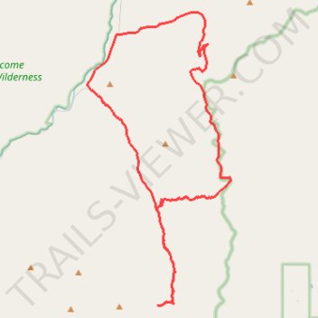
Ranch Creek Trail - Hogback Ridge - Brewster Creek Road
- Distance: 36.2 mi
- Elevation gain: 2,311 m
- Maximum elevation: 2,235 m
- Elevation loss: 2,314 m
- Minimum elevation: 1,172 m
Interactive trail map
Thank you for supporting this site ❤️
Make a donation
Make a donation
Gear up for your next adventure:
As an Amazon Associate, this site earns from qualifying purchases at no extra cost to you.
Trail profile
- Distance: 36.2 mi
- Elevation gain: 2,311 m
- Maximum elevation: 2,235 m
- Elevation loss: 2,314 m
- Minimum elevation: 1,172 m
Thank you for supporting this site ❤️
Make a donation
Make a donation
Gear up for your next adventure:
As an Amazon Associate, this site earns from qualifying purchases at no extra cost to you.
About this trail
Name: Ranch Creek Trail - Hogback Ridge - Brewster Creek Road trail, distance, elevation, map, profile, GPS track
Start: 1101, Rock Creek Road, Quigley, Granite County, Montana, 59825, United States (46.58140 -113.67135)
End: 1101, Rock Creek Road, Quigley, Granite County, Montana, 59825, United States (46.58143 -113.67156)
Coordinates: 46.46023 -113.67293 46.62324 -113.55722
Thank you for supporting this site ❤️
Make a donation
Make a donation
Gear up for your next adventure:
As an Amazon Associate, this site earns from qualifying purchases at no extra cost to you.