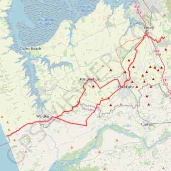
Import a GPX file

Karioitahi

#Bike #Loop #Pacific

  • Distance: 58.1 mi
  • Elevation gain: 1,066 m
  • Maximum elevation: 128 m
  • Elevation loss: 1,065 m
  • Minimum elevation: 5 m

Interactive trail map

Trail profile

  • Distance: 58.1 mi
  • Elevation gain: 1,066 m
  • Maximum elevation: 128 m
  • Elevation loss: 1,065 m
  • Minimum elevation: 5 m

About this trail

Name: Karioitahi trail, distance, elevation, map, profile, GPS track

Start: 229, MacWhinney Drive, Drury, Franklin, Auckland, 2577, New Zealand (-37.11810 174.98432)

End: 220, MacWhinney Drive, Drury, Franklin, Auckland, 2577, New Zealand (-37.11804 174.98436)

Coordinates: -37.28285 174.65482 -37.11389 174.98436

Other hiking, mountain biking, running and outdoor activity trails

Click on a trail to view its statistics, map and profile.

Drury - Kawakawa Bay

New Zealand > Auckland > Franklin > Drury

#Bike #Pacific

Distance: 51.0 mi • Elevation gain: 529 m • Maximum elevation: 120 m

Gear up for your next adventure:

🧵Survival Paracord - Multi-purpose cordage for emergency repairs and shelters
🧴Tick Removal Tools - Small, essential health tool for UK woodland and moorland
🔦Keychain LED Torches - Emergency backup light for finding gear in your pack
🛰️Outdoor GPS Navigation - Navigation devices for remote and off-grid areas
🥾Men's Waterproof Hiking Boots - Durable footwear with deep lugs for muddy and rocky UK terrains

As an Amazon Associate, this site earns from qualifying purchases at no extra cost to you.