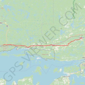
Import a GPX file

Spragge - Espanola

#Bike #Spragge #Espanola

  • Distance: 43.9 mi
  • Elevation gain: 409 m
  • Maximum elevation: 225 m
  • Elevation loss: 386 m
  • Minimum elevation: 179 m

Interactive trail map

Trail profile

  • Distance: 43.9 mi
  • Elevation gain: 409 m
  • Maximum elevation: 225 m
  • Elevation loss: 386 m
  • Minimum elevation: 179 m

About this trail

Other hiking, mountain biking, running and outdoor activity trails

Click on a trail to view its statistics, map and profile.

Espanola - South Baymouth

Canada > Ontario > Sudbury District > Espanola

Manitoulin Island. #Bike #Espanola #SouthBaymouth #Manitoulin

Distance: 66.2 mi • Elevation gain: 715 m • Maximum elevation: 272 m

Thessalon - Spragge

Canada > Ontario > Algoma District > Thessalon

Lake Huron. #Bike #Thessalon #Spragge #Huron

Distance: 52.0 mi • Elevation gain: 384 m • Maximum elevation: 236 m

Espanola - Sudbury

Canada > Ontario > Sudbury District > Espanola

#Bike #Espanola #Sudbury

Distance: 46.7 mi • Elevation gain: 451 m • Maximum elevation: 280 m

Gear up for your next adventure:

🧷Tenacious Repair Tape - Instant fix for torn tents, jackets, or dry bags
🧰Survival Kits - Emergency tools for remote environments
Insulated Travel Mugs - Keep drinks hot while surveying the landscape from a summit
🐕Dog Hiking Gear - Equipment for hiking safely with dogs
🧼Biodegradable Soap - Leave-no-trace hygiene for multi-day mountain treks

As an Amazon Associate, this site earns from qualifying purchases at no extra cost to you.