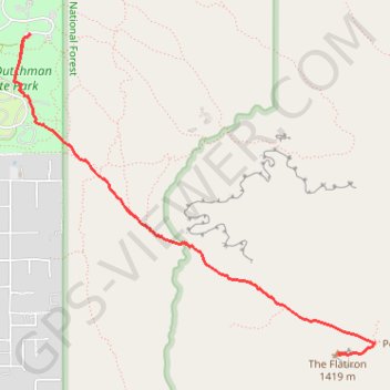
The Flatiron from Lost Dutchman State Park
Interactive trail map
Trail profile
- Distance: 5.6 mi
- Elevation gain: 820 m
- Maximum elevation: 1,428 m
- Elevation loss: 820 m
- Minimum elevation: 630 m
About this trail
Name: The Flatiron from Lost Dutchman State Park trail, distance, elevation, map, profile, GPS track
Start: Treasure Loop #56, Pinal County, Arizona, United States (33.45959 -111.47964)
End: Youngberg, Pinal County, Arizona, United States (33.45959 -111.47964)
Coordinates: 33.43757 -111.48079 33.45959 -111.45119
Other hiking, mountain biking, running and outdoor activity trails
Click on a trail to view its statistics, map and profile.
Massacre Falls Trail in Tonto National Forest and Superstition Wilderness
United States > Arizona > Maricopa County
Massacre Falls Trail in Tonto National Forest and Superstition Wilderness offers hikers a journey through desert landscapes adorned with seasonal wildflowers and panoramic mountain vistas. The trail leads to Massacre Falls, a seasonal waterfall best viewed after rainfall or during snowmelt periods. Along the…
Distance: 5.3 mi • Elevation gain: 354 m • Maximum elevation: 997 m
The Flatiron via Siphon Draw Trail in Tonto National Forest
United States > Arizona > Pinal County > Youngberg
The Flatiron via Siphon Draw Trail offers a challenging and rewarding hiking experience within the stunning Superstition Mountains of Tonto National Forest. The route begins with a rocky ascent through exposed terrain, gradually drawing you closer to the dramatic Flatiron peak, which stands out like the bow of…
Distance: 5.7 mi • Elevation gain: 835 m • Maximum elevation: 1,424 m
Treasure Loop Trail in Tonto National Forest
United States > Arizona > Pinal County
The Treasure Loop Trail in Tonto National Forest offers hikers a scenic journey through the Sonoran Desert, featuring expansive vistas of the Superstition Mountains and the Goldfield Mountains. Along the path, you can observe diverse cacti species, including saguaro and prickly pear, set against a backdrop of…
Distance: 2.4 mi • Elevation gain: 164 m • Maximum elevation: 804 m