Mount Ramon - Mount Arif
הר רמון להר עריף: הכי רחוק מציוויליזציה וארוך מספיק לזקק
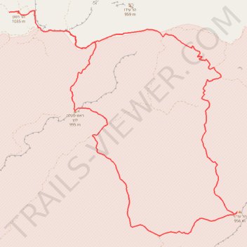
- Distance: 26.7 mi
- Elevation gain: 1,159 m
- Maximum elevation: 1,030 m
- Elevation loss: 1,159 m
- Minimum elevation: 667 m
- Moving time: 12 h 10 m
- Moving speed: 2.2 mph
- Maximum speed: 2.5 mph
- Total time: 12 h 10 m
- Global speed: 2.2 mph
Interactive trail map
Trail profile
- Distance: 26.7 mi
- Elevation gain: 1,159 m
- Maximum elevation: 1,030 m
- Elevation loss: 1,159 m
- Minimum elevation: 667 m
- Moving time: 12 h 10 m
- Moving speed: 2.2 mph
- Maximum speed: 2.5 mph
- Total time: 12 h 10 m
- Global speed: 2.2 mph
About this trail
Name: Mount Ramon - Mount Arif trail, distance, elevation, map, profile, GPS track
Coordinates: 30.41611 34.63163 30.50302 34.73317
Other hiking, mountain biking, running and outdoor activity trails
Click on a trail to view its statistics, map and profile.
Mount Ramon and Mount Ido
Israel > South District > Ramat Negev Regional Council
הר רמון והר עידו מעלה: הפריזמות ומעלה ערוד באזור הכי על-הירח שיש
Distance: 12.2 mi • Elevation gain: 667 m • Maximum elevation: 1,030 m
Mount Arif - Mount Karkom
Israel > South District > Ramat Negev Regional Council
הר עריף להר כרכום: הכי מרוחק ופראי שיש
Distance: 21.5 mi • Elevation gain: 1,036 m • Maximum elevation: 930 m
Ramon and Lotz
Israel > South District > Ramat Negev Regional Council
הר רמון ולוץ: בורות לוץ ומעלה לוץ
Distance: 16.6 mi • Elevation gain: 578 m • Maximum elevation: 1,030 m