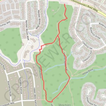
Import a GPX file

Warbler Woods Loop

#Hiking #Running #Loop #Warbler

  • Distance: 1.1 mi
  • Elevation gain: 40 m
  • Maximum elevation: 297 m
  • Elevation loss: 40 m
  • Minimum elevation: 268 m

Interactive trail map

Trail profile

  • Distance: 1.1 mi
  • Elevation gain: 40 m
  • Maximum elevation: 297 m
  • Elevation loss: 40 m
  • Minimum elevation: 268 m

About this trail

Name: Warbler Woods Loop trail, distance, elevation, map, profile, GPS track

Start: Thames Valley Trail, London, Ontario, N6K 4A5, Canada (42.96542 -81.35280)

End: Thames Valley Trail, London, Ontario, N6K 4A5, Canada (42.96540 -81.35281)

Coordinates: 42.95875 -81.35544 42.96542 -81.35233

Gear up for your next adventure:

🌄Compact Monoculars - Lightweight optics for hiking
🌄Outdoor Binoculars - Compact binoculars for landscape observation
🥾Walking Shoes - Lightweight walking shoes for countryside and coastal paths
🎒Multi-day Trekking Packs - Large capacity backpacks for wild camping and long-distance trails
🧴Sport Sunscreen Sticks - High-protection sunblock that won't run into your eyes on the trail

As an Amazon Associate, this site earns from qualifying purchases at no extra cost to you.