Import a GPX file

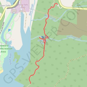
Hayward Lake - Steelhead Falls

#Hiking

  • Distance: 2.3 mi
  • Elevation gain: 158 m
  • Maximum elevation: 143 m
  • Elevation loss: 159 m
  • Minimum elevation: 80 m

Interactive trail map

Trail profile

  • Distance: 2.3 mi
  • Elevation gain: 158 m
  • Maximum elevation: 143 m
  • Elevation loss: 159 m
  • Minimum elevation: 80 m

About this trail

Other hiking, mountain biking, running and outdoor activity trails

Click on a trail to view its statistics, map and profile.

Vancouver - Golden

Canada > British Columbia > Metro Vancouver Regional District > Vancouver

#Bike #Vancouver #Golden

Distance: 514.2 mi • Elevation gain: 9,376 m • Maximum elevation: 1,347 m

Gear up for your next adventure:

📍Handheld GPS Navigators - Reliable satellite navigation for hiking and off-road exploration
Insulated Travel Mugs - Keep drinks hot while surveying the landscape from a summit
🧗Locking Carabiners - Secure gear to your pack or for light technical use
📻Hand-Crank Emergency Radios - Stay updated on weather warnings in remote areas
🧷Tenacious Repair Tape - Instant fix for torn tents, jackets, or dry bags

As an Amazon Associate, this site earns from qualifying purchases at no extra cost to you.