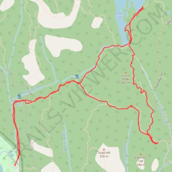
Lunch Peak and Peden Lake loop from Sooke River in Sea to Sea Regional Park
- Distance: 5.2 mi
- Elevation gain: 356 m
- Maximum elevation: 381 m
- Elevation loss: 364 m
- Minimum elevation: 89 m
- Moving time: 2 h 20 m
- Moving speed: 2.2 mph
- Maximum speed: 5.1 mph
- Total time: 3 h 4 m
- Global speed: 1.7 mph
Interactive trail map
Trail profile
- Distance: 5.2 mi
- Elevation gain: 356 m
- Maximum elevation: 381 m
- Elevation loss: 364 m
- Minimum elevation: 89 m
- Moving time: 2 h 20 m
- Moving speed: 2.2 mph
- Maximum speed: 5.1 mph
- Total time: 3 h 4 m
- Global speed: 1.7 mph
About this trail
Name: Lunch Peak and Peden Lake loop from Sooke River in Sea to Sea Regional Park trail, distance, elevation, map, profile, GPS track
End: Sooke River Road, Sooke, Capital Regional District, British Columbia, Canada (48.43989 -123.71700)
Coordinates: 48.43986 -123.71739 48.45489 -123.69660