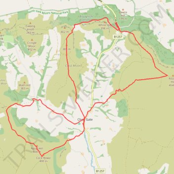
Chop Gate Double Mountain Biking Loop
- Distance: 14.9 mi
- Elevation gain: 779 m
- Maximum elevation: 445 m
- Elevation loss: 779 m
- Minimum elevation: 158 m
- Moving time: 2 h 45 m
- Moving speed: 5.4 mph
- Maximum speed: 35.0 mph
- Total time: 3 h 12 m
- Global speed: 4.6 mph
Interactive trail map
Trail profile
- Distance: 14.9 mi
- Elevation gain: 779 m
- Maximum elevation: 445 m
- Elevation loss: 779 m
- Minimum elevation: 158 m
- Moving time: 2 h 45 m
- Moving speed: 5.4 mph
- Maximum speed: 35.0 mph
- Total time: 3 h 12 m
- Global speed: 4.6 mph
About this trail
Name: Chop Gate Double Mountain Biking Loop trail, distance, elevation, map, profile, GPS track
Coordinates: 54.37712 -1.18880 54.42715 -1.08922
Topography: North Yorkshire topographic map, elevation, terrain
Other hiking, mountain biking, running and outdoor activity trails
Click on a trail to view its statistics, map and profile.
Vantage_M3_2026_07_31_13_14_30
United Kingdom > England > North Yorkshire > Chop Gate > Seave Green
Distance: 16.6 mi • Elevation gain: 889 m • Maximum elevation: 445 m
2026-07-31 13:11
United Kingdom > England > North Yorkshire > Chop Gate > Seave Green
File with points/tracks from Locus Map/4.35.0
Distance: 16.7 mi • Elevation gain: 919 m • Maximum elevation: 444 m