Make a donation
Gear up for your next adventure:
As an Amazon Associate, this site earns from qualifying purchases at no extra cost to you.
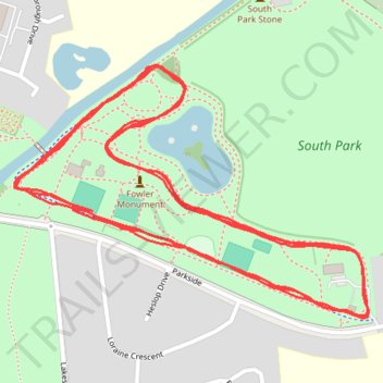
Darlington South Park parkrun
- Distance: 3.1 mi
- Elevation gain: 29 m
- Maximum elevation: 46 m
- Elevation loss: 30 m
- Minimum elevation: 38 m
- Moving time: 24 m 28 s
- Moving speed: 7.6 mph
- Maximum speed: 11.2 mph
- Total time: 24 m 28 s
- Global speed: 7.6 mph
Interactive trail map
Make a donation
Gear up for your next adventure:
As an Amazon Associate, this site earns from qualifying purchases at no extra cost to you.
Trail profile
- Distance: 3.1 mi
- Elevation gain: 29 m
- Maximum elevation: 46 m
- Elevation loss: 30 m
- Minimum elevation: 38 m
- Moving time: 24 m 28 s
- Moving speed: 7.6 mph
- Maximum speed: 11.2 mph
- Total time: 24 m 28 s
- Global speed: 7.6 mph
Make a donation
Gear up for your next adventure:
As an Amazon Associate, this site earns from qualifying purchases at no extra cost to you.
About this trail
Name: Darlington South Park parkrun trail, distance, elevation, map, profile, GPS track
Start: Parkside, Skerne Park, Darlington, Tees Valley, England, DL1 5TQ, United Kingdom (54.51491 -1.56090)
End: Parkside, Skerne Park, Darlington, Tees Valley, England, DL1 5TQ, United Kingdom (54.51488 -1.56042)
Coordinates: 54.51338 -1.56231 54.51694 -1.55371
Topography: Darlington topographic map, elevation, terrain
Make a donation
Gear up for your next adventure:
As an Amazon Associate, this site earns from qualifying purchases at no extra cost to you.