Thank you for supporting this site ❤️
Make a donation
Make a donation
Gear up for your next adventure:
As an Amazon Associate, this site earns from qualifying purchases at no extra cost to you.
McCullough Gulch Trail
Interactive trail map
Thank you for supporting this site ❤️
Make a donation
Make a donation
Gear up for your next adventure:
As an Amazon Associate, this site earns from qualifying purchases at no extra cost to you.
Trail profile
- Distance: 6.4 mi
- Elevation gain: 508 m
- Maximum elevation: 3,830 m
- Elevation loss: 508 m
- Minimum elevation: 3,360 m
Thank you for supporting this site ❤️
Make a donation
Make a donation
Gear up for your next adventure:
As an Amazon Associate, this site earns from qualifying purchases at no extra cost to you.
About this trail
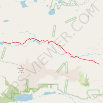
Name: McCullough Gulch Trail trail, distance, elevation, map, profile, GPS track
Start: McCullough Gulch Road, Summit County, Colorado, United States (39.39784 -106.06777)
End: McCullough Gulch Road, Summit County, Colorado, United States (39.39784 -106.06777)
Coordinates: 39.39784 -106.11508 39.40783 -106.06777
Thank you for supporting this site ❤️
Make a donation
Make a donation
Gear up for your next adventure:
As an Amazon Associate, this site earns from qualifying purchases at no extra cost to you.