Bella Coola - Snooka trail - west
Bella coola, bc
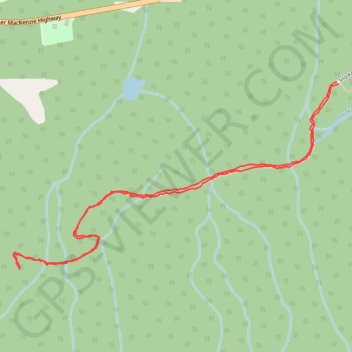
- Distance: 3.2 mi
- Elevation gain: 226 m
- Maximum elevation: 212 m
- Elevation loss: 227 m
- Minimum elevation: 28 m
- Moving time: 1 h 42 m
- Moving speed: 1.9 mph
- Maximum speed: 3.8 mph
- Total time: 1 h 52 m
- Global speed: 1.7 mph
Interactive trail map
Trail profile
- Distance: 3.2 mi
- Elevation gain: 226 m
- Maximum elevation: 212 m
- Elevation loss: 227 m
- Minimum elevation: 28 m
- Moving time: 1 h 42 m
- Moving speed: 1.9 mph
- Maximum speed: 3.8 mph
- Total time: 1 h 52 m
- Global speed: 1.7 mph
About this trail
Name: Bella Coola - Snooka trail - west trail, distance, elevation, map, profile, GPS track
Coordinates: 52.35298 -126.68334 52.36151 -126.65898