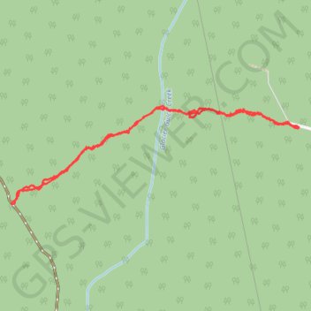
Trail near Twin Falls, Smithers BC
- Distance: 1.8 mi
- Elevation gain: 74 m
- Maximum elevation: 581 m
- Elevation loss: 74 m
- Minimum elevation: 530 m
- Moving time: 39 m 37 s
- Moving speed: 2.7 mph
- Maximum speed: 10.4 mph
- Total time: 57 m 59 s
- Global speed: 1.8 mph
Interactive trail map
Trail profile
- Distance: 1.8 mi
- Elevation gain: 74 m
- Maximum elevation: 581 m
- Elevation loss: 74 m
- Minimum elevation: 530 m
- Moving time: 39 m 37 s
- Moving speed: 2.7 mph
- Maximum speed: 10.4 mph
- Total time: 57 m 59 s
- Global speed: 1.8 mph
About this trail
Name: Trail near Twin Falls, Smithers BC trail, distance, elevation, map, profile, GPS track
Coordinates: 54.84648 -127.26306 54.84988 -127.24585
Other hiking, mountain biking, running and outdoor activity trails
Click on a trail to view its statistics, map and profile.
Track 20240827-154422
Canada > British Columbia > Regional District of Bulkley-Nechako > Area A (Hudson Bay Mountain)
Distance: 10.2 mi • Elevation gain: 319 m • Maximum elevation: 605 m