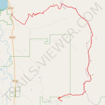
Napa point to wire
- Distance: 26.3 mi
- Elevation gain: 1,379 m
- Maximum elevation: 2,343 m
- Elevation loss: 2,263 m
- Minimum elevation: 941 m
- Moving time: 5 h 17 m
- Moving speed: 5.0 mph
- Maximum speed: 30.0 mph
- Total time: 7 h 8 m
- Global speed: 3.7 mph
Interactive trail map
Trail profile
- Distance: 26.3 mi
- Elevation gain: 1,379 m
- Maximum elevation: 2,343 m
- Elevation loss: 2,263 m
- Minimum elevation: 941 m
- Moving time: 5 h 17 m
- Moving speed: 5.0 mph
- Maximum speed: 30.0 mph
- Total time: 7 h 8 m
- Global speed: 3.7 mph
About this trail
Name: Napa point to wire trail, distance, elevation, map, profile, GPS track
Start: Napa Point Road, Lake County, Montana, United States (47.78323 -113.72788)
End: Lake County, Montana, United States (47.90895 -113.83392)
Coordinates: 47.78244 -113.83506 47.92175 -113.66186