Thank you for supporting this site ❤️
Make a donation
Make a donation
Gear up for your next adventure:
As an Amazon Associate, this site earns from qualifying purchases at no extra cost to you.
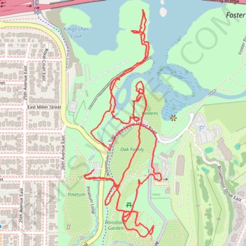
Washington Park North Arboretum Ramble
- Distance: 2.3 mi
- Elevation gain: 38 m
- Maximum elevation: 29 m
- Elevation loss: 37 m
- Minimum elevation: 3 m
- Moving time: 28 m 32 s
- Moving speed: 4.7 mph
- Maximum speed: 8.5 mph
- Total time: 28 m 32 s
- Global speed: 4.7 mph
Interactive trail map
Thank you for supporting this site ❤️
Make a donation
Make a donation
Gear up for your next adventure:
As an Amazon Associate, this site earns from qualifying purchases at no extra cost to you.
Trail profile
- Distance: 2.3 mi
- Elevation gain: 38 m
- Maximum elevation: 29 m
- Elevation loss: 37 m
- Minimum elevation: 3 m
- Moving time: 28 m 32 s
- Moving speed: 4.7 mph
- Maximum speed: 8.5 mph
- Total time: 28 m 32 s
- Global speed: 4.7 mph
Thank you for supporting this site ❤️
Make a donation
Make a donation
Gear up for your next adventure:
As an Amazon Associate, this site earns from qualifying purchases at no extra cost to you.
About this trail
Name: Washington Park North Arboretum Ramble trail, distance, elevation, map, profile, GPS track
Coordinates: 47.63777 -122.29764 47.64466 -122.29419
Thank you for supporting this site ❤️
Make a donation
Make a donation
Gear up for your next adventure:
As an Amazon Associate, this site earns from qualifying purchases at no extra cost to you.
Other hiking, mountain biking, running and outdoor activity trails
Click on a trail to view its statistics, map and profile.
Biking around Seattle
United States > Washington > King County > Seattle
Distance: 29.6 mi • Elevation gain: 407 m • Maximum elevation: 55 m